Areas with a Distinctive Shared Historic Association and Character
Areas with a Distinctive Shared Historic Association and Character
As part of the 2016 Historic Resources Survey, nine areas of Belmont were identified as having a distinctive shared historic association and/or character. Below is a brief description of each of these areas. More information on these distinctive areas, or the Historic Resources Survey in general, can be found in the Final Report.
Images below that depict buildings currently listed in the Massachusetts Cultural Resource Information System (MACRIS) have been linked to their corresponding pages within that database. Simply click the image to learn more about that particular building.
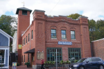
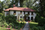
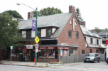
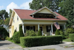
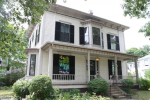
Belmont Center
|
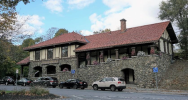
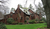
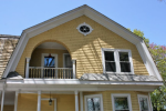
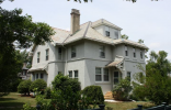
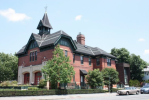
Belmont Hill
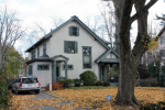
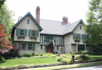
The Belmont Hill section of town is located to the northwest of Belmont Center. It is bounded roughly by Concord Avenue to the south, Clifton Street and Clairemont Road to the east and Marsh Street to the west while extending north nearly to Rt. 2. The area has historically attracted some of the town’s most substantial dwellings, set on large estate-like parcels of land. Belmont Hill was developed gradually beginning in the 19th century. Several significant brick Georgian Revival mansions were constructed by the Atkins family in the early 20th century. The Belmont Hill Company laid out a series of nine subdivisions in various sections of Belmont Hill beginning in 1920 and construction continued into the latter 20th century. Due to its extended period of development Belmont Hill displays a wide range of architectural styles ranging from early Federal and Second Empire houses to Colonial, English Revival and International Style dwellings. |
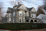
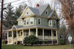
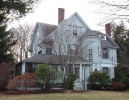
Belmont Park
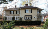
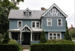
Located southeast of Belmont Center, Belmont Park is a late 19th century residential subdivision consisting of lots measuring less than a quarter of an acre. The tree-lined neighborhood is located on the south side of Concord Avenue and includes Myrtle and Oak Streets as well as sections of Goden, School and Orchard Streets. Because most of the lots were developed between 1894 and 1899, the Belmont Park neighborhood exhibits a remarkable sense of architectural cohesiveness and historical integrity, dominated by similar dwellings displaying characteristics of the Queen Anne, Shingle and Colonial Revival styles. |
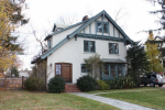
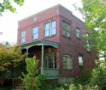
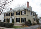
Clark Hill
The Clark Hill section of Belmont is located south of Belmont Center and is bordered on the east by Common Street, on the south by Waverley Street, on the west by Thomas Street and on the north by Clark Street. Although development first occurred in the mid-19th century, the neighborhood largely reflects the subdivision of the area by the Belmont Associates in 1909. Many of the homes built on the resulting Blake, Clover and Kilburn Streets exhibit an English Revival or Craftsman aesthetic. The hilltop location, spacious lots with extensive landscaping and stone walls enhance these architect-designed dwellings and give the neighborhood a distinctive, picturesque character. |
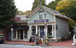
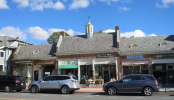
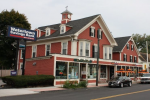
Cushing Square
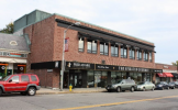
Cushing Square is one of Belmont’s three commercial centers and is located at the intersection of Common Street, Trapelo Road and Cushing Avenue in the south-central part of Belmont, near the Watertown line. The irregular lines of the roadways translate to oddly-shaped lots and buildings that give the neighborhood center a unique character. The commercial structures largely date to the early 20th century and include a wide range of styles including English Revival, Classical Revival and Colonial Revival examples. Some of the buildings reflect the architecture of nearby residential structures while others are examples of the simple commercial structures seen in many of Boston’s streetcar suburbs. |
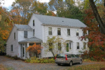
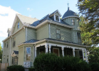
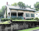
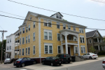
Payson Park
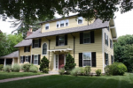
Payson Park is a late 19th century residential subdivision located in the southern part of Belmont, near the Watertown line and the Cushing Square commercial center. It is bounded on the south by Trapelo Road, on the west by Common Street, and on the north and east by Payson Road. Most of the land was developed between 1886 and 1920 and thus, the area includes homes in a wide variety of styles including the Queen Anne, Colonial Revival, English Revival and Craftsman. |
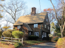
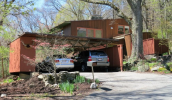
Snake Hill
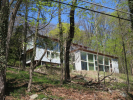
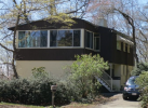
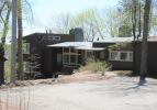
The Snake Hill neighborhood is located on a steep hillside north of Pleasant Street and west of Belmont Center. Developed by architect Carl Koch in the early 1940s, it is considered to be one of the earliest and most significant Modern house neighborhoods in the country. The neighborhood consists of seven houses on Snake Hill Road. |
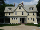
Walnut Hill
The Walnut Hill area is located near the center of Belmont and is bounded on the west by Common Street, north by Fairmont Street, east by Goden Street and south by Hillcrest Road. Initially laid out in 1910, it was developed over more than twenty years, giving it a diversity of architectural styles. Many of the homes have beautifully landscaped settings. |
Waverley
The Waverley section is located in the southwest corner of Belmont, near both the Waltham and Watertown town lines. It includes Waverley Square, one of the town’s three commercial centers, as well as various residential neighborhoods with resources dating from the mid 19th to 20th century. The Waverley section of Belmont has seen many changes since its origins as a rural settlement in the mid 19th century. Lexington, Belmont and North Streets (now Trapelo Road) were early transportation routes. The arrival of the Fitchburg Railroad in 1843 opened up the area for development and growth increased as Waverley became a railroad center and then a streetcar suburb. |